Category Archives: travel to machu picchu

Choquequirao archaeological complex – Cusco – Peru

It is an Inca urban construction, which archaeological studies may be better specifying in the future, as its architectural structure and functions are analyzed. Only archaeologists will determine if there is material evidence with greater antiquity in the same location.56 In a general sense, the Andean populated centers especially Inca also called liadas, are characterized by being fixed according to a distribution pattern: square; a number of large, elongated and rectangular buildings called kallankas; deposits or collqas; platforms or ushnu cradle in their squares for the cult of the Sun and probably to carry the agricultural calendar with more precision (Thompson 1972: 78; cf. also Ayme Carrasco 2003: 237-38, 250-53). According to ethnohistorians, these populated centers followed the model of the city of Cusco, where the ritual and ceremonial spaces had the solar temple, royal apartments and, what we could call, a civil administrative part: prisons, acllahuasis, warehouses (Espinoza 1997b : 362; cf. also Rostworowski 2004: 173). However, it cannot be asserted that there was a general and constant pattern for all urban settlements, Choquequirao is also a good example of the adaptation in a steep and high terrain of a llacta that conserves the fundamental elements, but adequate to a certain area of construction. INFORMATION OF CHOQUEQUIRAO TREK

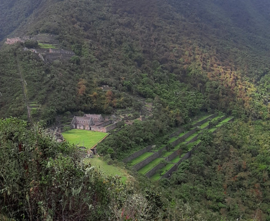
The urban layout, as seen by archaeologists, follows the dual Andean pattern. There is a high sector: hanan, and another low part, hurin. In this regard, archaeologists Roberto Samanez and Julinho Zapata point out:

When studying the distribution of functions in Choquequirao, a dual organization is perceived, very widespread, which creates a high sector and another low part or Hurin. It has been established that the High Sector is the one occupied by the buildings in the extreme North, and the Low sector is the one next to the main square where ceremonial buildings are located, the three two-level buildings and the two Kallankas. (Samanez and Zapata 1999: 90)

Choquequirao is built following a north-south axis with a drop of 65 meters in height between the first and second planes. Each plan has three groups of constructions that are distributed following the topographic disposition of the terrain. The central area of ​​the complex, probably ceremonial, is 700 meters long.

MORE INFORMATION OF CHOQUEQUIRAO TREK


GENERAL INFORMATION OF THE AUSANGATE MOUNTAIN

Popular Adventure Programs in Nevado Ausangate

  1. Ausanagate Trek 5 Days
  2. Ausangate Circuit 6 Days
  3. Ausangate Walk and Sibinacocha Lagoon 7 Days

The snow of Ausangate is the fifth highest in Peru and the most representative of the Andes. It is located in the Vilcanota mountain range, it is one of the most difficult areas to access.

The highest peak of this snowfall passes 6,000 meters above sea level, in this place there are large lagoons with blue and green colors, there are also rocks that cause the area to be like a paradise and very modern. This is a very attractive place for people who practice adventure sports, thanks to its geographical accidents it is possible to practice climbing and trekking.

The snowy Ausangate is the representative mountain of Cusco and the Peruvian Andes. It is located in the Vilcanota mountain range and is one of the most difficult areas to visit which makes it a fabulous route to venture. Its main climate is 6,372 meters above sea level, with large green / blue lagoons. In addition there are rocks that make the area like a paradise. Performing the Ausangate trek is an indescribable adventure, and it is impossible not to be impressed by the enormous beauty of eternal snow. Often you will find mountains of a height of more than 5000 meters and also rocks covered with tongues of ice, spreading in magnificent forms forming ice lagoons. The Ausangate walk is one of the tourist destinations in Cusco.
In the Inca mythology of this mountain and the nearby lakes – among which Sibinacocha stands out – the masculine energy that fertilizes Mother Earth Pachamama is born, after a long course, the waters are lost in the unknown lands of the Amazon to return, to fill the lakes and glaciers every night turned into the river of stars or Willkamayu known in the West as the Milky Way The Community of Chillca constituted by shepherds of llamas and alpacas is known as the guardian of these pristine places, from where you can do mountain walks spending the night in comfortable hostels or tambos, among which Machuracay Tambo stand out, in a walk called “Path of the Apu Ausangate”.
Every year on the north side of the Ausangate, the festival of Quyllur Rit’i (Quechua: “star snow”) is celebrated before the feast of Corpus Christi, during which thousands of inhabitants make pilgrimages to the Lord of Quyllur Rit’i in the church from Sinakara. The Ausangate snowy usually takes 7 days tours, it is an adventure that no one should miss.


AUSANGATE TREK INFORMATION

The first attempt to ascend the snow of Ausangate, was at the beginning of the 50’s, being the first 2 attempts frustrated. It had to wait until 1953, for a German expedition to reach the top of the Apu, ascending on the south side. Later, new routes were implemented to climb to the top of the mountain. Only in 1983, Peruvian feet reached the top of the snow.

Location

It is located in the district of Ocongate, in the province of Quispicanchi, belonging to the department of Cusco in the Vilcanota mountain range.

Climate and temperature

The predominant climate of the area is cold, at night it reaches temperatures below 5 ° C, by day it can be up to 20 ° C, it also has cold winds during parts of the day. In the area there are also rains and snowfall.

Altitude

The maximum peak of the Ausangate snowfall is 6,372 meters above sea level.

How to get to Ausangate Snowy

There are 2 routes to get to the mountain, the first is to go by bus from Cusco to the town of Chilca, from here you can take a walk from 4 to 5 hours to the Base Camp.The other route is a bit longer but cheaper, this is to go from Cusco to the town of Tinki by bus and then take a bus to Pacchanta. From this point along the steel gorge, it is 8 to 10 hours to the Ausangate Base.

adventure sports

  1. Ausangate Trek
  2. Climbing

Coyllur Riti party

Between the snow-capped mountains of Ausangate and Sinakara, is the Coyllur Riti Shrine, popularly known by the inhabitants of the area as Taytacha Coyllur rit’i, whose meaning is Lord of the Shining Snow. Every year here in the months of May or June, the Coyllur Riti festival has been celebrated since ancient times. Celebration during which thousands of Quechua pilgrim to the Lord of Coyllur Riti. This ritual is associated with the fertility of the land and with the worship of the Apus (hills, gods, guardians), one of the largest indigenous nations of America is celebrated.


All About Salkantay Mountain – Cusco – Peru (part 3)

Location of the snowy mountain of Salkantay:

The Salkantay Route, also known as the “New Inca Trail”, is located north of the city of Cusco, following the Cusco – Limatambo – Abancay – Lima road, making a detour between Limatambo and Mollepata.

Salkantay snowy climate:

It is very sunny during the day, but cold at night. The temperature drops below 0 ° C at night during the months of June to September. In the season from December to March it is very rainy so it is not recommended to go on these dates.

The best time to do this trek is during the months of March to September.

Height of the walk to the snowy Salkantay

This hike reaches a height of 4,600 meters above sea level at its highest point is on the slopes of the same snowy Salkantay. Enter Ausangate 5D Snowy Walk to do this little walk.

How to get to the snowy mountain of Salkantay

The buses from Cusco to Mollepata leave very early from 4 am to 5 am and pass through Limatambo, from Mollepata is where the trek to the snowy Salkantay begins, after climbing a step it is possible to have an impressive pyramidal view of Salkantay, one of the mountains most beautiful snowfall of Cusco.

From Mollepata it takes two days to descend to Huayllabamba and join the second day of the Inca Trail.

What you will see along the way

On the way you can see herds of cattle and sheep, orchids, bear with glasses, medicinal plants of the Inca eponca, small variety of birds, fruit trees such as orange, papaya, bananas, and so on.

Note: The eye of the glasses to see it is necessary to have some luck.

recommendations

It is very important for the traveler. Bring your original passport for the respective controls.

RECOMMENDED MONTHS TO TRAVEL

March: (a little rain)
From April to October: (an excellent trip)
From October to November: (a little rain)
December to February: (lots of rain)

SALKANTAY TREK INFORMATION


All About Salkantay Mountain – Cusco – Peru (part 2)

Note: There is, in my opinion, a controversy regarding the paternity of the first ascent of this crest S.E., since it consists in the previous realization of a powerful group of Japanese who achieved the ascent by this route. Unfortunately, the only reference found in this Japanese ascension dates from an Iwa magazine to Yuki, written, of course, in Japanese, so without a translation of the text there is no concrete data.

Humantay Mountain – Salkantay Route To Machu Picchu

The western edge of the Salkantay is a route that remains virgin after years given the complexity of its layout and the distance from the traditional approach points, which requires additional porting based on the dragging of backpacks.

According to the prestigious Pyrenean Louis Audoubert, who ascended to the top by the northern slope in 1977, the west edge is feasible, but it will certainly be a good problem to solve at the Andean level.

This crest was attempted in 1975 by a group of Catalan climbers from Mataró formed by Manuel Punsola and Mitjans, Miquel Sala and Roy, Xavier Varela and Pinart, Ramón Armengol and Carbó, Antoni Sors and Farre, Antoni Rosa and Olivera and Vicente Aris and Julta .

On August 5, 1975, three members of this expedition approached the edge by an additional buttress of the northern slope that had been previously recognized. They go up for a good part of the day until they reach a point with two possibilities that seem unattainable. The logic was to tackle the ice ridge, something impossible given the lack of material means. The other option would be to flank the slopes of the ridge to look for the hill between the two Salkantay peaks.

At a certain point of this great flanking, which they calculate, it will take them a whole day, they decide to leave due to the large number of avalanches that leave the ridge and that are obviously a first order objective danger. Catalan climbers believe that the difficulties so far have not been important or dangerous, but moving away from the obvious route of the ridge, which would require more human and material equipment, greatly increases the risk.

Coming from Mollepata the first vision we will have of Salkantay is in its overwhelming south face a huge wall that closes the bottom of the valley with its vertical seracs hanging from huge rocky spurs, this wall could not fail to attract the attention of those who try to complicate a little their lives for pure personal satisfaction, so in 1970 a powerful group of Germans from the Munich DAV composed of Walter Welsh, J.Vogt, H.Koebrich, H.Haver and M.Olzowy made a meritorious attempt on the left side of the wall, leaving quite high on the crest that descends to the western summit of Salkantay.

In 1986 an English group led by J.Lowe broke through this hillside attacking the rocky base to the right of the German attempt of the 1970s. The snow zone continued a slight diagonal to the right until it reached the eastern peak of the mountain.

On June 15, 1978, a powerful Slovenian expedition of the Planinska Zveza, composed of Libor Anderle, Zoran Breslin, Marjan Brisar, Edi Torkar, Jure Zvan and Jure Ulcar, accompanied by Dr. Borut Pirc and Matjaz Derzaj as coordinator, opened in a week Exploring and climbing an intelligent route along the eastern slope of the mountain, the Slovenian route, which without detracting from the difficulty, is the most feasible option of trying to reach the top.

The second ascent to this route was made by the Mexican Roberto Morales Puebla and companion on June 17, 1978 and the third by Los Vascos de San Sebastián, Iñígo and Jesús Mª Barandiarán, José Luís Conde and Jesús Mª Rodríguez accompanied by Alberto Cabezón and José Antonio Fernández de Aranguiz on July 3 of the same year, which makes it the first ascent of mountaineers in the Spanish State.

The Salkantay has been visited by mountaineers from around the world, French, Swiss, North American, New Zealander, Polish, Austrian, German, Mexican, Slovenian, Slovenian, Spanish (Asturian, Basque, Andalusian, Catalan)…. that have crossed its steep slopes… some lived the light of the reward from the top … others, a great majority, had to withdraw when the chance of triumph among the cornices escaped.

SALKANTAY TREK TO MACHU PICCHU INFORMATION