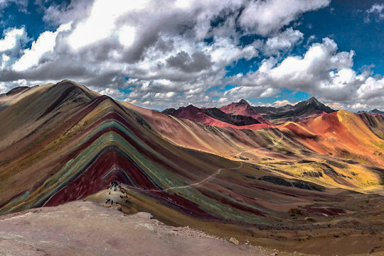
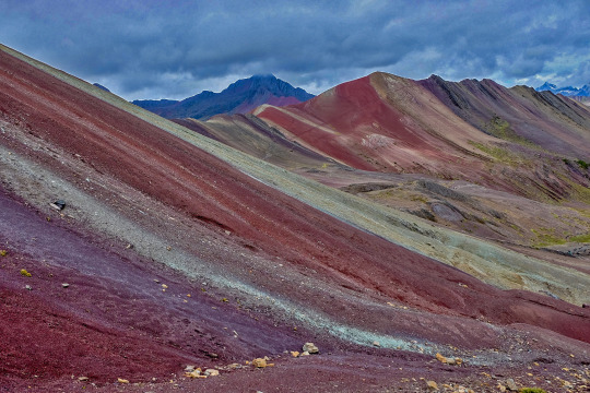
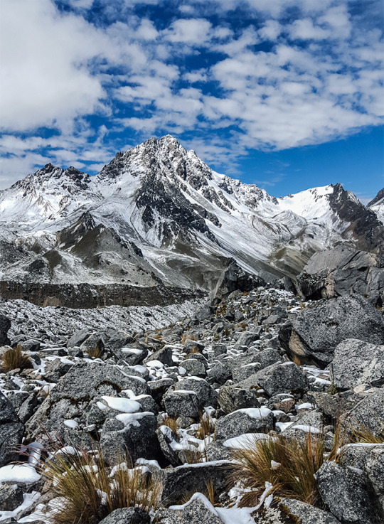
According to the research, the coloration of the rainbow mountain is due to the composition of minerals that it has: the pink color is for the red clay, fangolitas and arilitas. The whitish, for the quartzose sandstone and marls, rich in calcium carbonate. The red is composed of the clay (iron) and clays belonging to the upper tertiary. The green is due to the compound of phyllites and clays rich in ferro magnesian. The earthy brown is a product of fanglomerate composed of rock with magnesium belonging to the Quaternary era. And the mustard yellow color for the calcareous sandstones rich in sulfur minerals, the vinicunca mountain is rich in all these minerals. RAINBOW MOUNTAIN INFORMATION
This first day we’ll leave Cusco very early for our three-hour trip in a private vehicle to the small village of Tinqui (3,800 meters). We will go by beautiful landscapes and several traditional villages as Urcos, Cattca and Ocangate. In Tinqui we will have lunch, after lunch we begin to walk through beautiful mountain landscapes with great views of Mount Ausangate. We walk for an average of 4 hours to reach the hot springs in Upis (4400 meters). In this place we will have dinner and spend the night.
DAY 2: UPIS – PUCA COCHA
After breakfast, we head to the first pass called the Abra Arapa (4850 meters). After passing the Abra we will have lunch, After lunch we continue on to Lake Pucacocha- a blue lake and a perfect stop for a break. Along the way you will see local herders and llamas, Ausangate mountain to your left, and you will have your expert guide explaining the history of the locals and talking about the landscape along the way. If you’re lucky you may see condors and vicuñas at our campsite where you will be surrounded by high mountains and incredible glaciers- watch for the Ausangate glacier crashing into the lake below! As always camp will be set up for you to change and rest your weary legs and dinner will be prepared.
DAY 3: PUCA COCHA — ANANTA
After breakfast, We will start with a steep ascent of Puca Cocha pass. While is partially difficult, this pass boasts incredible views the entire way. The higher you get the more impressive the lake is below and Ausangate mountain sitting directly across from we. Take some time to enjoy these beautiful views. We will have plenty of time to take wonderful and impressive photographs. After conquering the pass we continue through a vivid green valley with llamas grazing everywhere. As you approach our destination for the day we will have camp set up for you to enjoy your surroundings and relax.
We will wake you up extra early in the morning so you will can be the first people to the top of the Rainbow Mountain. After a hot breakfast, and some coca tea we will start with the first uphill climb- Ananta pass. Here you will see the beautiful Rainbow Mountain in the distance. From here you descend to a large valley and continue walking until we are presented with one final climb to the Vinicunca Mountain. We are going be the first ones at the Rainbow Mountain to enjoy the place at all with plenty of time for photographing, walk around and enjoy the beauty of the area. After we hike downhill for 2.5 hours to Qesoyuno where you have a delicious lunch surrounded by mountains. After lunch the car from the company will pick up us to drive back to cusco for 3.5 hours to take you back to your hotel.
WHAT TO BRING
A backpack
A beanie hat or ear warmer
Sun hat
Scarf
Gloves
A mid weight sweater
A longsleeve t-shirt
1 – 2 t-shirts
A lightweight suater or vest
A pair of long pants
Hiking shoes
An extra pair of shoe
2 – 3 pairs wool socks
A jacket
A small towel
Rain gear
1 – 2 pair shorts
Sunglasses
A small headlamp
Waterbottle
A toothbrust and other personal toiletries
Toilet paiper
Sun cream
Camera and film
Original passport (International Student Identity Card “ISIC” if applicable)
Extra money for drinks.
Emergency money at least 300-450 extra soles (USD$ 220)
Classic Salkantay trek 5 days is considered by most to be the best alternative route, This walk allows you to enjoy the options that there is in the salkantay route, you will go up to humantay lake, you will pass for the highets point of the salkantay route to be to see salkantay mountain up close, you hike through the santa teresa valley that is full of vegetation is the begining of the peruvian amazon, you have the chance to see, plantations of coffe, coca, avocados, bananas and much more, this valley is full of fresh wáter with many waterfalls and also if your choisce this hike, you will have enouth time do the relaxing hot springs of colcalmayo in santa teresa. and also you can do Llactapata hike on 4th day of the our advedventure, if you are an adventures person you got the chance to do the biggest and longest zipline of southamerica. choose this one and get a perfect adventures vacation to Machu Picchu. SALKANTAY TREK INFORMATION
Useful Information
– Starting Altitude – 3350 meters / 10990 feet . – Highest Altitude – 4600 meters / 15091 ft – Walking Distance – 12km / 7.45 miles – Campsite Elevation – 3920 meters / 12861 ft – Meals – 4 breakfast, 4 lunch, 4 dinner, 3 tea times, 3 wake up tea – Overall Difficulty – Moderate – Changing – STARTING POINT: – Cusco at your hotel
DIA 1 : Cusco – Mollepata – Humantay Lake – Soraypampa
We will leave Cusco approximately at 5:00 a.m. A bus will take us to the town of Mollepata (2900 meters above sea level) where we will arrive approximately at 7:30 in the morning, where you will have the chance to enjoy a delicious andean breakfast. After an hour aprox in Mollepata. we continue in the same car to the Trail head in Challacancha. There we will meet with our support staff. There we will organize all the equipment, horses and mules. Around 9:30 a.m. we will start our trek to Soraypampa (3850 m.a.s.l) the first section of the path are paved rock trail there are the old water channel still supply to new habitants, the begin is 8 km in 3 hours to Soraypampa the lunch place as well base camp, after lunch and nap to continued hiking up to the Humantay lake (4200 masl) 3 km in 2 hours round trip, bottom the glacier the most spectacular views to the back ground valley and sunset, Soraypampa is located on the middle of the glaciers valleys at night clear appreciate the constellation on the sky.
DAY 2: Soraypampa – Salkantay Pass- Huayracmachay – Chaullay
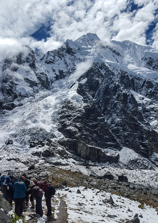
The second day of the salkantay trek is considerat the hardest day. This is because the hiking distance is 22km/ 14 ft and also on this day you will get up to the highest point of the salkantay trail 4630 m / 15225 ft. in this day in order to make it on time to the second campsite. we’re going wake up with coca tea at 5:00 to enjoy a dilisious breakfast after we get ready for the trek. Around 6:30 in the morning we start hiking to the highest point of the whole salkantay trail. After 4 hours hike you reach to the top to celebrate and enjoy a beautifull views of the salkantay mountain once at the top you have the chance to make a offering for the APUS (andean gods). From 4630 m / 15225 ml. We start hiking downhill to get 2900 m / 9510 ml in todo 15 km downhill hiking. we are going to do in two sections. The first section will be from the top to the lunch point which takes 2 hours approximately and then after lunch 3 hours more to the second camp call chawllay. on the way you are going apreciate diferent type of landscapes such glaciar mountains, lagoons, roccky mountains, grassy hill, by the time that you will be close to the camp you are going be in the jungle area. Once at the camp time to relaxing if you like you can enjoy cold beers while the cooks make the te time and the delicious dinner. ANOTHER SALKANTAY TREK ITINERARY
DAY 3: Chaullay – La Playa – Santa Teresa (2nd option camp in Lucmabamba)
You will hike through the jungle are of Santa Teresa. The valley is formed by the salkantay river that discures from the white mountain. In this valley you have the opportunity to see waterfalls, rivers, plantations like coca, coffee, avocado, passion fruit, bananas and much more is a tropical valley and the climate is quite warm. After of our breakfast we will start the trek to the town of sahuayco, after 5 hours of crossing through the dense vegetation we arrived at the lunch point and then we drove to Santa Teresa camp to visit the thermal hot springs of Santa Teresa. After a three days hiking is quite relaxing to spend some time at the pools couple of hours in the thermal baths then we return to the camp to take tea and the last camp dinner and spend the last nights in the tent.
Option: camp in Lucmabamba – Llactapata
After lunch at Sahuyaco (Playa), we will hike for approximately one hour to our base camp called Lucmabamba. We will explore the tropical forest for a little while and have a lovely visit at an organic coffee farm. Here you can taste the coffee prepared by the local people. We will also explore an orange and an avocado plantation.
DAY 4: Santa Teresa – Hidroelectrica – Aguas Calientes (Llactapata – Aguas Calientes)
According the itinerary you will hike 3 hours from Santa Teresa to Hidroelectrica but the hike is along the car road, some people do not like road hike. If you do not want to take this option you can choose the nexts ones.
By car to hidroelectrica: You may take a car fron santa teresa to hidroelectrica for 45 minutes
Zipline: you can do zipline with one of the companies that ofert this activity in one of the valeys of santa teresa. after zipline you go by car to hidroelectrica. Any option that you may take usually we start at 6:00 am with breakfast then around 8 am we start the activities.
After lunch at Hidroelectrica we will hike 3 hours more to aguas calientes town on the flat trail. Then we take you to the hotel for showering and relaxing, in the evening around 7:00 pm we organised a dinner in a restaurant in Aguas Calientes after dinner we go to sleep to climb Machu Picchu early on the next day.
Option: Lucmabamba – Llactapata – Aguas Calientes
After our breakfast, we will make our trek uphill to the Inca ruins of Lacctapata, after visiting this wonderful place, we will make the trek downhill to Hidroelectrica where we will have our lunch. From Hidroelectrica we will go to the town of Aguas Calientes.
DAY 5: MACHU PICCHU – CUSCO
After an early breakfast at the hotel, we walk uphill to Machu Picchu at 5:00 am. or take the bus from Aguas Calientes to Machu Picchu (Optional bus $16 each way), upon arrival at the Citadel we can appreciate the enigmatic beauty and the incomparable example of architectural perfection and hydraulics of one of the 7 Wonders of the Modern World, we will have a guided tour of about 2 hours, where we can appreciate the Main Plaza, the Circular Tower, Intihuatana, The Royal Quarters, the Temple of the Three Windows and the Cemetery, you are then given free time to stroll around the citadel . You will have all morning in Machu Picchu to take pictures, maybe to climb the Wayna Picchu or Machu Picchu Mountain, enjoy this mystical place. Then we´ll descend by bus to Aguas Calientes for lunch and then calmly return by train to Ollantaytambo where our tourist transport to the city of Cusco will be expecting us, and will later transfer you to your hotel. OTHER ACTIVITIES:
Climb up Huayna Picchu and appreciate the beauty and magnificence of Machu Picchu from there (We recommend that you book in advance) Not Included
Climb Machu Picchu Mountain and appreciate the beauty and magnificence of Machu Picchu from there (We recommend that you book in advance) Not Included
Visit the new local museum or the hot springs in Aguas Calientes later in the day. Not Included
– Meals: Breakfast – Tour: 2 hour guided tour of Machu Picchu
WHAT TO BRING
A backpack
A beanie hat or ear warmer
Sun hat
Scarf
Gloves
A mid weight sweater
A longsleeve t-shirt
1 – 2 t-shirts
A lightweight suater or vest
A pair of long pants
Hiking shoes
An extra pair of shoe
2 – 3 pairs wool socks
A jacket
A small towel
Rain gear
1 – 2 pair shorts
Sunglasses
A small headlamp
Waterbottle
A toothbrust and other personal toiletries
Toilet paiper
Sun cream
Insect repelent
Camera and film
Original passport (International Student Identity Card “ISIC” if applicable)
Extra money for drinks.
Emergency money at least 300-450 extra soles (USD$ 220)
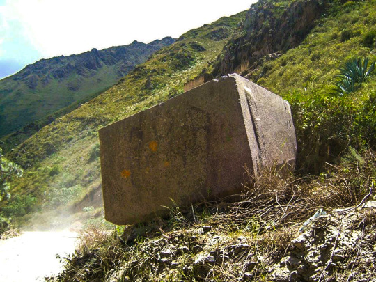
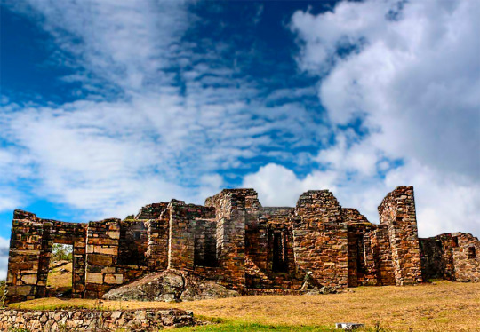
The quarry of Cachicata was the place of extraction of the stones that were used for the construction of Ollantaytambo and many surrounding areas. This place is 9 kilometers from the Inca town of Ollantaytambo and has three groups of quarries: Molle Pucro, Sirkusirkuyoc (it was the largest), shows evidence of having been in full operation when the Spaniards entered this area. And finally Kantirayoq or Cacchicata, where another type of extraction of minerals and precious stones was practiced. CACHICATA TREK INFORMATION
Useful Information
– Starting Altitude – 3350 meters / 10990 feet . – Highest Altitude – 4500m / 14,764ft – Walking Distance – 25 km / 15.5 miles – Meals – 4 breakfast, 3 lunch, 3 dinner, 3 tea times, 3 wake up tea – Overall Difficulty – Moderate – STARTING POINT: – Cusco at your hotel
DAY 1: CUSCO – SOQMA – RAYAN
We will come to pick you up at 5:00 a.m. from your hotel in Cusco City, and we will drive along a road to the Pachar Valley close to Ollantaytambo. You will arrive at the starting point of your trek, Soqma village, after about 2 hours, where we will stop to have breakfast and meet our horseman. where we will stop to have breakfast and meet our horseman. We will start our hike up a lush valley of scattered farmhouses and crop terraces. After 40 minutes of walking, we will see a tall waterfall where we can pause to refresh ourselves amidst the cool spray of the waterfall. After a refueling lunch, we will ascend 45 minutes until our camp at Rayan (3,700 meters/12,136 ft).
DAY 2: RAYAN – INTI PUNKU – CHOQUETACARPO
After breakfast, we ascend 3 hours to the first pass of the trek, known as Puccaqasa (4,370 m/ 14,333 ft). where we will have spectacular views of the valley. We will encounter a stunning view of Ollantaytambo and the Sacred Valley. We then head downhill for 25 minutes to our lunch location. After lunch, we hike 2 hours with alternating ascents and descents. The final 20 minutes of this segment will take us uphill to the highest pass of the trek, Kuychicassa (4,457 m/ 14,619 ft), From here we trek downhill for 2 hours to a site the Incas called Inti Punku, where there is a spectacular view of Mount Veronica (5,682 m/ 18,637 ft) and the Sacred Valley of the Incas. Our campsites is 30 minutes downhill from Inti Punku at Choquetacarpo (3,600m/ 11,808 ft).
DAY 3: CHOQUETACARPO – OLLANTAYTAMBO – AGUAS CALIENTES
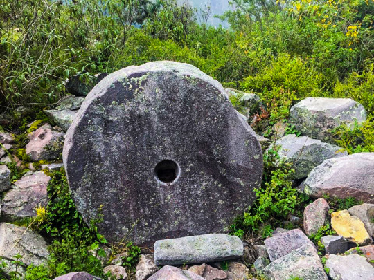
After early breakfast and then we will walk one hour downhill to the Inca quarry of Cachicata (3420m/11286ft). Here, you can see the work of the Incas as this was used by the Incas for the construction of Ollantaytambo. You will see several large buildings, quarried stones left half finished and abandoned throughout the site.We will have lunch facing a breathtaking mountain and valley panorama. After We will continue our hike for 3 and a half hours downhill to Ollantaytambo, where you will have some time to rest and explore the historic town. In Ollantaytambo, we will catch the train to the town of Aguas Calientes. Once there, you will have a dinner at a restaurant in the town and discuss with your guide what time you wish to wake up in the morning. Your hostel in Aguas Calientes can be upgraded to a hotel if you prefer.
DAY 3: MACHU PICCHU – CUSCO
After an early breakfast at the hotel, we walk uphill to Machu Picchu at 5:00 am. or take the bus from Aguas Calientes to Machu Picchu (Optional bus $16 each way), upon arrival at the Citadel we can appreciate the enigmatic beauty and the incomparable example of architectural perfection and hydraulics of one of the 7 Wonders of the Modern World, we will have a guided tour of about 2 hours, where we can appreciate the Main Plaza, the Circular Tower, Intihuatana, The Royal Quarters, the Temple of the Three Windows and the Cemetery, you are then given free time to stroll around the citadel . You will have all morning in Machu Picchu to take pictures, maybe to climb the Wayna Picchu or Machu Picchu Mountain, enjoy this mystical place. Then we´ll descend by bus to Aguas Calientes for lunch and then calmly return by train to Ollantaytambo where our tourist transport to the city of Cusco will be expecting us, and will later transfer you to your hotel. MORE INFORMATION OF CACHICATA TREK OTHER ACTIVITIES:
Climb up Huayna Picchu and appreciate the beauty and magnificence of Machu Picchu from there (We recommend that you book in advance) Not Included
Climb Machu Picchu Mountain and appreciate the beauty and magnificence of Machu Picchu from there (We recommend that you book in advance) Not Included
Visit the new local museum or the hot springs in Aguas Calientes later in the day. Not Included
– Meals: Breakfast – Tour: 2 hour guided tour of Machu Picchu
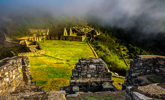
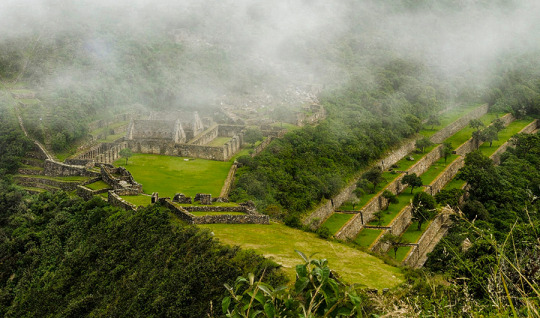
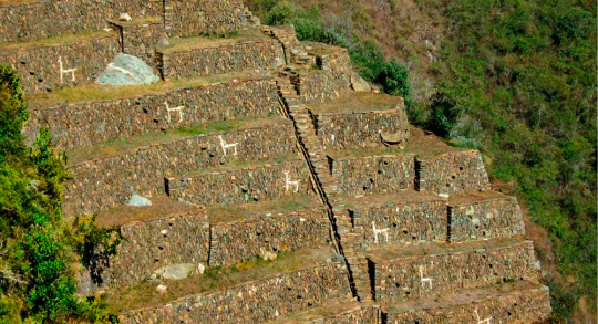
Choquequirao known as the sacred sister of Machu Picchu because it has a structural and architectural similarity, archaeological monuments are made up of terraces distributed on different levels which were leveled and fenced with stones to form a platform with an approximate area of 150 square meters.
The Choquequirao ruins are located at 13 ° 32 ’latitude and 77 ° 44’ west longitude, it is located at 3033 masl in the mountains of the snowy Salkantay north of the Apurímac river in the district of Santa Teresa province of the department of Cusco.
How to get
Currently to reach the last Inca fortress is the land route, the best known route of how to get to Choquequirao is by taking the road to Abancay, and at km 154 choose the detour that will direct you to the town of Cachora.
The route to Choquequirao has narrow paths which must be walked very carefully, also have a good physical condition and the proper equipment for this trek.
Weather
Due to its height, Choquequirao enjoys a temperate climate. However, it should be noted that the Choquequirao path is warm due to the Apurímac canyon.
Description
Choquequirao (comes from the Aymara words chuqui, gold, and from Quechua k’iraw, cradle, that is to say: “cradle of gold”), is another of the archaeological zones also known as the Inca citadel, it is located between the ramifications of the Nevado de Salcantay, southern Peru. These archaeological remains of Choquequirao are made up of a set of buildings and terraces distributed on different levels, from the lower Sunch’u Pata level to the highest truncated summit, which was leveled and fenced with stones to form a platform with an area approximately 150 square meters.
Choquequirao (sometimes also referred to as Choqequirau or Choquekiraw), is also known as the “sacred sister” of Machu Picchu for the structural and architectural similarities presented with it. Well, not too long ago it became known about this majestic place, thus awakening the interest of many tourists and researchers.
Biodiversity
The environment of Choquequirao is one of the richest in biodiversity, biologists, ecologists and experts mention this, however in this area, the number of species of plants and animals that exist is not known exactly, despite this deficiency and From the few scientific studies carried out, it has been possible to determine the existence of various life forms.
Among the most relevant species are: the condor, the fox, the skunk, the puma, the spectacled bear, the taruca, the vizcachas, the pica pica, the tall toucan, the quetzales and the tigrillos. All these species have been conditioned despite the temperature variations such as the sun throughout the day and the inclement frosts at night. This space can also be seen to the cock of the rocks, Peru’s national bird.
The flora of the place is made up of giant ferns and a great variety of orchids, where the wakanki variety stands out. At the bottom of the great valley and under the thermal effect of the water course that runs through it, the forests of the mountain eyebrow provide their warmth and ideal conditions for a huge variety of crops of coca, annatto, corn, cocoa, coffee and fruit trees.
From the environmental point of view, the main value of these presented ecosystems resides in the role played by the exuberant forests that grow in the high parts of the mountains for the maintenance of the water balance of the region, capturing the rainwater and leading it without causing erosion towards the Apurimac River. MORE INFORMATION OF CHOQUEQUIRAO TREK TO MACHU PICCHU
This ancient Inca city is known as the younger sister of the Wonder of the World. Some tourists who made the 2-day hike to visit it even say that Choquequirao is better. It is true? Learn the truth about this new archaeological site in Cusco, Peru. CHOQUEQUIRAO TREK ITINERARY
What is Choquequirao really?
Choquequirao is an Inca urban center with features common to others in Cusco, especially Machu Picchu.
The similarity with Machu Picchu is largely due to the similarity of the geography of the place where the enclosure was built.
According to various investigations, Choquequirao would also be a fortress and a ceremonial center. The truth is that due to its hidden location in a high and distant mountain; It was a strategic point for various purposes.
Over the years, like Machu Picchu, Choquequirao was abandoned and covered by the jungle until its re-discovery.
Is it worth visiting Choquequirao?
The only way to get to Choquequirao is on foot. There are 3 days of roads (round trip) including the tour of Choquequirao.
The trek to Choquequirao makes visiting this inaccessible place a difficult but memorable adventure.
Once in Choquequirao, the tourist will be practically alone with an archaeological site as spectacular as Machu Picchu.
The few tourists in the world who visited Choquequirao agree that it was worth it.
Where is Choquequirao located?
Choquequirao is located at 3,103 meters above sea level. in a privileged location: it lies on the impressive canyon of the Urubamba river.
It is located in the foothills of the snowy Salkantay, in the Apurímac valley, in the province of the Convention in Cusco, Peru.
What does Choquequirao mean?
Choquequirao means ‘Cradle of Gold’ in Quechua. It is considered the ‘Sister city of Machu Picchu’, due to its similarities to the Inca City.
In truth, its architecture is as impressive as that of Machu Picchu.
At the moment Choquequirao has the advantage of not receiving the number of visitors that its “older sister” receives.
Few people know Choquequirao. Perhaps due to the difficult walk it takes to get there.
What is the architecture like in Choquequirao?
Choquequirao has numerous Inca buildings. However, currently only 30% of its entire area has been excavated.
Its most important buildings are quartzite, cut in great detail. The rest of the walls are made of raw stone.
These walls were covered with clay both inside and outside.
The Choquequirao walls are believed to have been painted light orange. Although in reality there are few structures that continue with this coating.