Tag Archives: journey

All About Salkantay Mountain – Cusco – Peru (part 1)

Also known as Salkantay, Peru’s snowy peak located in the department of Cuzco, it is one of the main elevations of the Vilcabamba Range, an extension of the Eastern Cordillera, a mountainous branch of the Peruvian Andes. It reaches an altitude of 6,271 meters. It has two snowy peaks, known as China Salkantay and female Salkantay, separated by a port that opens to the Santa Ana Valley in the province of Urubamba. Both the mountain pass and the course of the river that is born there are called Salkantay. This river pours its waters into the Urubamba on its left bank.

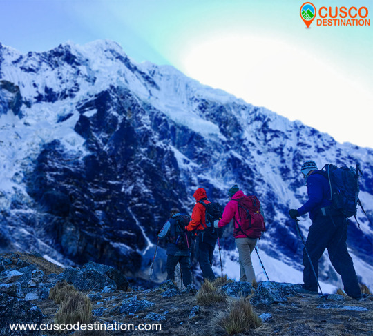
Our company has the Salkantay Trek, a walk that will take you to Machu Picchu.

Hence the name of Snowy Salkantay:

The name of this mountain is a contraction that comes from Salga = sullen or wild and Antay produces bees or avalanches. It is usually preceded by the name of Apu, which in Quechua language comes to mean sir, is defined as large mountains that mean something sacred above the valleys. For example, Apu Salkantay in the Vilcabamba mountain range.

Snowy Salkantay (6,271) Source: Musical Henares, S.L. (Alcalá de Henares – Madrid)

The great white Apu. A little stories between ropes and crampons:

The Salkantay is one of the highest mountainous regions of the Qosco (Cusco). The highest mountain is the Gran Agusánate with 65 meters more in the Vilcanota mountain range located further south. However, and without a doubt, it is the greatest in its splendid isolation and in the greatness of its double-headed massif, to which is added the fact of being one of the mountains of this magnificent Andean region that presents greater technical problems for all its slopes This is evidenced by the six itineraries opened to date by the different slopes of this white giant.

His conquest dates from 1952 by the Swiss cordate composed of Bronimann and Marx.

This first ascent, like so many others in the history of mountaineering, is involved in several contradictions, since a few days later it is promoted again by a Franco-American expedition that included the well-known and relevant mountaineer of the Claude Kogan era.

Modern statistics merit being the first woman on top of the Italian Consuelo Bonaldi who climbed Cresta Este on August 4, 1978 accompanied by G.Marconi, A.Monononi, F.Nodari, S.Castellani, Augusto Zanotti and M.Quatrinni, obviously this is a mistake, since Claude Kogan did it 26 years before.

The Salkantay summit has two peaks, the East and the West, formerly the West, more slender and attractive than the East, which was slightly taller because it was crowned by a seracoa. After the passing of the years and the collapse of this serac, as the prestigious Pyrenean Louis Audoubert has pointed out, the height is practically identical in both peaks.

What happened in those two consecutive “first ascents” gave rise to the controversy that it had really been the first real one.
The Swiss went up in the fog to the top of the East (the lowest in those days), the Americans however went up to the West, which was somewhat higher so the statistics, always relentless, want to deny Bronimman and Marx his first absolute ascension.

In 1953 he was climbed for the third time by the prestigious Alpine guide Lionel Terray, who together with the Dutch T. de Booy and the Swiss Raymond Jenny defeated the summit following a route along the northern ram, now known as the Terray Ram.

Years later, a German expedition tries the top following the dangerous crest of the N.E. which, with its cornices, does not favor traffic … a relevant rope formed by Tony Mazenauer and Fritz Kasparrek (the latter conqueror of the north face of the Eiger) disappears on this ridge and the expedition has to be withdrawn.

Today there is a plaque commemorating that unfortunate event under the passage of Palcay (the usual base camp of the mountain) and on a block of visible rock.

On August 23, 1975, it was the turn of a long and steep crest of the S.E. of an Australian-New Zealand expedition composed of Peter Jennings, Wayne Barton and Michael Andrews. This ascent was the ninth to the top.

More options for Cusco Treks


Inca quarry of Cachicata Ollantaytambo – Cusco

This place was dedicated to the extraction and carving of the stones that were used for the construction of Ollantaytambo and many surrounding precincts. This place is located about 14 km from the Inca town of Ollantaytambo and has three groups of quarries: Molle Pucro, Sirkusirkuyoc (it was the largest of the three), shows the evidence of having been fully operational when the Spanish arrived in this area . And finally Cacchicata or Kantirayoq, where another type of extraction of minerals and precious stones was practiced. Visitors can observe the great work done at the time of moving the giant stones to build Ollantaytambo enclosures. We can find the stones called “Tired Stones” that were on their way to Ollantaytambo and in some parts of the city.

INCA QUARRY TREK INFORMATION

Cachicata or Inca quarry is one of the old quarries used by the pre Inca and Inca civilizations to build the vast complexes of Ollantaytambo. It was a source of large amounts of pink granite. Cachicata quarries are 14 km from Ollantaytambo. The view of Ollantaytambo from the quarries is spectacular and during the walk you can see many large stones that remained in the middle of their long trip to the village. It was also a commercial route for the Incas. Cachicata is a small and remote town that can benefit from the occasional visit of tourists.

The Hike to Cachicata is a great alternative to the famous Inca Trail hike. This road was built by the Incas and used for hundreds of years to access local communities and transport goods. This trail is not as well known as the Classic Inca Trail, so much less crowds and a more serene trekking experience in Peru are expected. This hiking adventure not only visits Peru’s cultural past, but also explores modern Inca communities and customs. The trail takes us through isolated waterfalls, ancient terraces and exotic wildlife, while offering fantastic views of the Sacred Valley and its snowy mountains. Visit with local families and explore an active quarry. Each step brings a new look to the Inca culture.

How long is Ollantaytambo?

The trip from the city of Cusco to the Inca city of Ollantaytambo is approximately 1 hour and 30 minutes in private mobility but if you wish to travel in the public transport units the approximate time is 2 hours.

Can you climb to the Inca quarry of Cachicata without a guide?

The Walk to the Inca quarry of Cachicata being part of the Inca road circuit that runs through the country of Peru, and the circuit of Qhapap Ñan, it is recommended that it be carried out with the supervision of an authorized agency that provides the professional guide service so that you can enjoy the best way to hike and take a nice memory to your country.

How high is Inti Punku “Puerta del Sol”?

Inti Punku or «Puerta de Sol» is the highest point on the hike to the Inca quarry being at a height of approximately 3886 meters from that point you can see an impressive view of the Sacred Valley and the Snowfall that are around as are the snow Veronica.

What should I take to make the walk to the Inca quarry of Cachicata?

To make the walk without any inconvenience we recommend the following:

  • A lightweight backpack to carry your stuff.
  • Water bottle.
  • Money for snacks, souvenirs and tips if you want to tip.
  • Hat, sunscreen and sunglasses
  • Jumper (sweater)
  • Protection against rain (or plastic poncho) the Cusco region can experience “all seasons in one day”, therefore, it is advisable to wear a hat and gloves, as well as a sun hat, when you go out tomorrow, in order to be prepared for all eventualities.

Is a tourist ticket needed for the Inca Quarry of Cachicata?

At the moment no income is being collected, which will allow you to discover more freely the path of the Incas to the Inca quarries of Cachicata.


The different colors of the Rainbow Mountain in Cusco

Many people ask the question of why the Colors of the Rainbow Mountain, in this article we will answer all your questions and you will find some other things.
The Vinincunca mountain of colors has come to fame very quickly, becoming one of the most visited tourist places in Peru by tourists from all over the world, for the great attraction of its colors and its beautiful landscape view of its snow-capped mountains that has captivated More than one visitor, if we look up at the horizon we will be able to see the rocky mountains, the red valley, that if they could speak for sure they would tell us a lot of stories from past times and tourists who visit it day by day. RAINBOW MOUNTAIN INFORMATION:

The concern to know the reason for its colors leads us to ask ourselves many questions and to obtain the answers we go back to approximately 24 million years ago.

Rainbow Mountain Formation Processes

The formation of the 7-color mountain according to studies dates from the Campanian era, which is part of the geological era belonging to the Cretaceous; where the continents were already separated and many of them covered with seas, so the seven-colored mountain was also covered with shallow sea.

Geological era of the Cretaceous and Paleocene

After many millions of years the Cretaceous geological era goes down in history with the extinction of the dinosaurs, as a result of the fall of a meteorite, so the climatic conditions begin to change and some seas dry up, that is where the geological era of the paleócene many mountains covered with sea are discovered and among them the mountain of seven colors appears, the mountains that appeared in the light were massive rocks that with the climatic conditions of many millions of years these have been eroding and becoming different colors according to its composition elements.

If we visit the Vinincuca mountain and approach the safety rope that protects the mountain, we will be able to observe that it is not really fine colored sand as we might think, but rather it is particles of rocks in the process of erosion.

If we do not have the opportunity to get closer to the mountain, we can be very observant along the way, we will surely find some eroded colored rocks, there we can better observe and feel them.

Among its colors we can find the following composition:

  • Pink color: Composition of red clay, mud and sand.
  • Off-white color: White quartz sandstones
  • Brown, brown and purple color: Composed of limonites and marls, rich in calcium carbonate.
  • Red color: Composed of clays and clays rich in iron
  • Green color: Composed of phyllites and clays rich in magnesium iron.
  • Brown color: They are earthy is a product of rock fanglomerate with magnesium.
  • Mustard yellow color: Composed of calcareous sandstones rich in sulfur minerals.

ALL INFORMATION OF RAINBOW MOUNTAIN AND AUSANGATE