Tag Archives: machu picchu

The snowy Salkantay: information about the Salkantay trek

MORE TOURS IN CUSCO TO MACHU PICCHUOne of the most incredible ways to visit Machu Picchu is through the Salkantay trek. This 5-day and 4-night hiking route crosses the imposing snow-capped Salkantay and then reaches the Wonder of the World. Would you like to know Machu Picchu with this adventure surrounded by amazing landscapes? Know everything you need to know about the Salkantay trek.

What does Salkantay mean?
The Salkantay is a snowy mountain whose name translated from Quechua would mean ‘Wild Mountain’. This summit is known as ‘Apu’ (‘Lord’) for its majesty and elevation.

Where is it located?
The pu Apu ’Salkantay is located in the Vilcanota Mountain Range in the Andes of southern Peru. This snow-capped mountain is the second largest in Cusco, after Ausangate (Mountain of the 7 Colors).

How high is the snowy Salkantay?
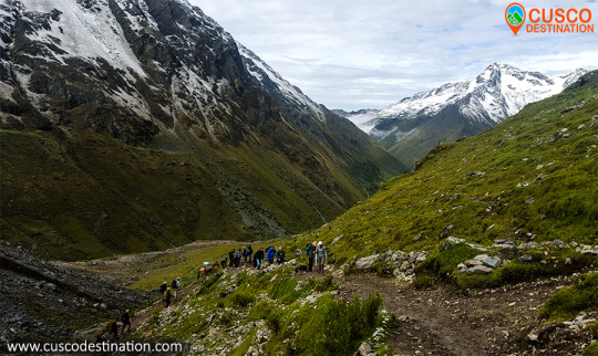
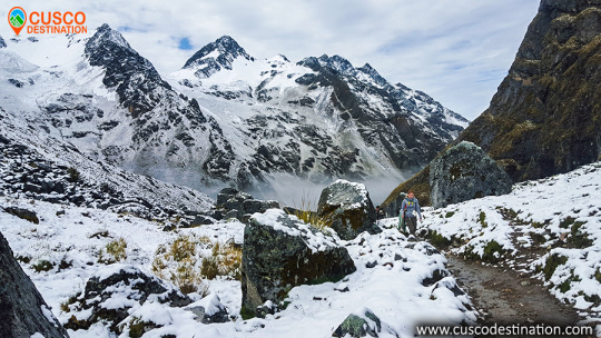
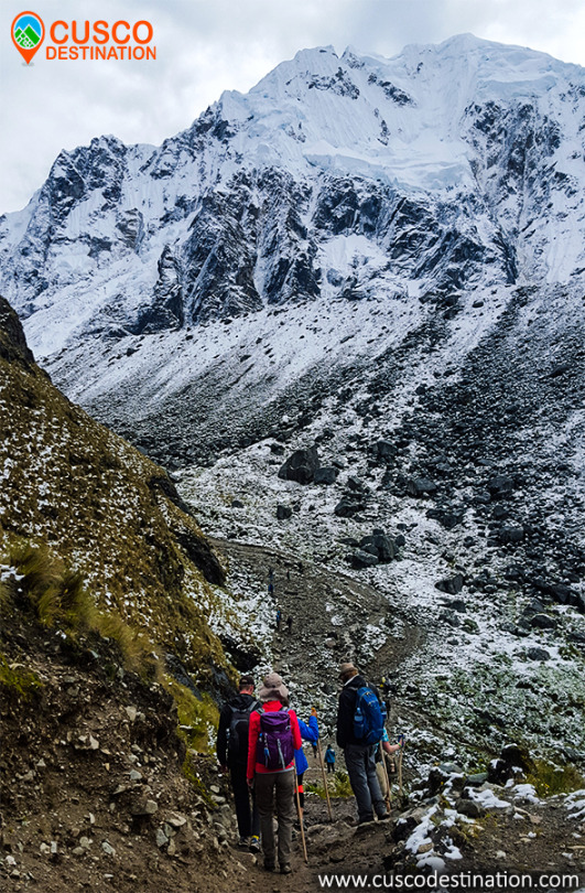
The snowy Salkantay reaches 6,271 meters above sea level (m.s.n.m.). The trek route that leads to Machu Picchu has its highest point in the ‘Abra Salcantay’, at 4,650 m.a.s.l. From there you can see the peak of the snowy peak.

How’s the weather?
The snowy in itself presents an extremely cold climate (several degrees Celsius below 0º).

The climate during the Salkantay trek, on the other hand, is varied. The intense sun and the nightly cold in the early days are changed by the tropical environment in the latter.

What is the flora and fauna like?
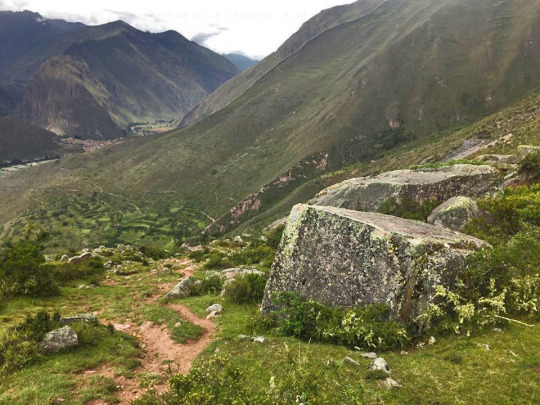
The 5 days and 4 nights of the Salkantay trek cover landscapes with a great variety of flora and fauna. Among the species of flowers and plants, the orchid and the ichu (Andean grass) stand out. Among the species of birds and animals, it is worth mentioning the llama, alpaca, vizcacha, condor, spectacled bear and the cock of the rock (national bird of Peru)

Salkantay trek: everything you need to know

What is the Salkantay trek?
The Salkantay trek is a hiking route that takes the visitor to the Inca City of Machu Picchu. The total walking distance is approximately 70 kilometers (5 days of route).

The Salkantay trek is considered among the 25 best excursions in the world by National Geographic Adventure Travel Magazine.

Classic Salkantay trek 5 days is considered by most to be the best alternative route, This walk allows you to enjoy the options that there is in the salkantay route, you will go up to humantay lake, you will pass for the highets point of the salkantay route to be to see salkantay mountain up close, you hike through the santa teresa valley that is full of vegetation is the begining of the peruvian amazon, you have the chance to see, plantations of coffe, coca, avocados, bananas and much more, this valley is full of fresh wáter with many waterfalls and also if your choisce this hike, you will have enouth time do the relaxing hot springs of colcalmayo in santa teresa. and also you can do Llactapata hike on 4th day of the our advedventure, if you are an adventures person you got the chance to do the biggest and longest zipline of southamerica. choose this one and get a perfect adventures vacation to Machu Picchu.

Useful Information

– Starting Altitude – 3350 meters / 10990 feet .
– Highest Altitude – 4600 meters / 15091 ft
– Walking Distance – 12km / 7.45 miles
– Campsite Elevation – 3920 meters / 12861 ft
– Meals – 4 breakfast, 4 lunch, 4 dinner, 3 tea times, 3 wake up tea
– Overall Difficulty – Moderate – Changing
– STARTING POINT: – Cusco at your hotel

IMPORTANT INFORMATION:

The snow-capped Salkantay is one of the highest mountains in Cusco, along with the Ausangate mountain in the Vilcanota mountain range which is located further south.
The Salkantay Trek to Machu Picchu is listed as one of the 25 best treks in the world by National Geographic Adventure Travel Magazine.
The Salkantay Trek is definitely one of the very best trekking adventures that you will find in Cusco and in Peru. After the Inca Trail classic or Inca Trail short, the Salkantay route is the 2nd most popular to Machu Picchu (and a lot less crowded).
Machu Picchu is one of the 7 Wonders of the Modern World, Heritage of Humanity, Historical Sanctuary of Peru and probably the most important archaeological site in Latin America.
Machu Picchu is majestic architecture comprises 140 structures throughout the citadel.
Machu Picchu is was built by the Inca Pachacutec around the year 1460
After being forgotten, it was only in 1911 that the American Hiram Bingham reached Machu Picchu on an expedition and spread the site worldwide.

Brief Itinerary

– DAY 1: Cusco – Mollepata – Humantay Lake – Soraypampa
– DAY 2: Soraypampa – Salkantay Pass- Huayracmachay – Chaullay
– DAY 3: Chaullay – La Playa – Santa Teresa (2nd option camp in Lucmabamba)
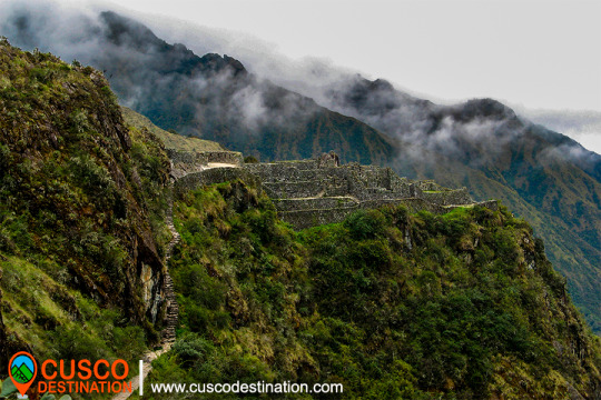
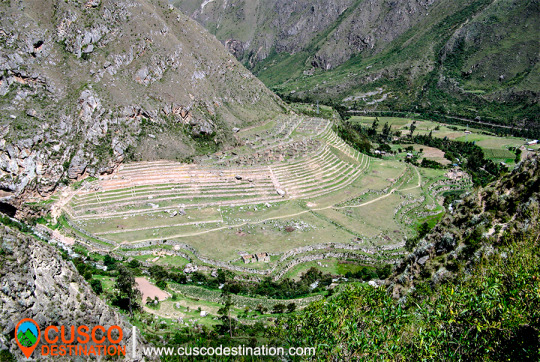
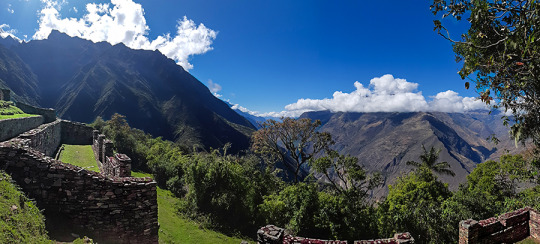
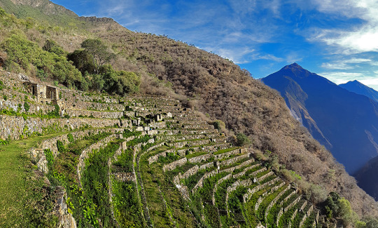
– DAY 4: Santa Teresa – Hidroelectrica – Aguas Calientes (Llactapata – Aguas Calientes)
– DAY 5: MACHU PICCHU – CUSCO

MORE TOURS IN CUSCO TO MACHU PICCHU


INCA TRAIL TO MACHU PICCHU

The Incas covered much of the South American continent. To maintain communication in such a vast territory, it was necessary to build a network of roads. Thus, the Inca ordered to build a network of roads called Qhapac Ñan (Inca Trail).

The Qhapac Ñan managed to cover up to 30 thousand kilometers from the current countries of Peru, Ecuador and part of Bolivia, Chile, Argentina and Colombia. The trekking route from the Inca Trail to Machu Picchu is only a small part of the extensive network of roads of the Qhapac Ñan.

The Inca Trail to Machu Picchu

The Inca Trail was revealed to the world in 1915 when it was being excavated in the Inca City. Three decades later, the route was traced by the Viking expedition in 1942. Today, thousands of visitors decide to travel the 43 kilometers to the ‘Puerta del Sol’ in Machu Picchu.

However, Machu Picchu is not the only archaeological site that you will see on the Inca Trail. On the tour you will also appreciate the ruins of Llactapata, the archaeological site of Runkurakay, Saycamarca, Phuyupatamarca and Wiñaywayna.

There are trains and buses that can take you directly to Machu Picchu. However, the experience of arriving as the Incas did for centuries is unmatched.

Versions of the Inca Trail to Machu Picchu

Not all people have the days necessary to travel the Inca Trail (4 days and 3 nights). That is why there are 3 versions depending on the time you have:

  1. Classic Inca Trail: 4 days and 3 nights (43 kilometers of walking).
  2. Imperial Inca Trail: 5 days and 4 nights (43 kilometers of walking).
  3. Short Inca Trail: 2 days and 1 night (12 kilometer walk).

About tickets to enter the Inca Trail

Due to the high demand for tickets, you must get the entrance tickets to the Inca Trail well in advance (6 months). The purchase is made only online through the website of an authorized tourism agency.

In total 500 people enter the trails of the Inca Trail every day. Of these, only 200 are tourists. The rest are support staff such as cooks, porters, guides. The ticket to enter the Inca Trail includes support staff.

Did not find availability to do the Inca Trail? 

The only way to enter the Wonder of the World is by train through the Sacred Valley of the Incas or by the alternative route from Santa María to Machu Picchu. Entrance tickets to Machu Picchu must also be reserved in advance.

Do you want to enter the Huayna Picchu after the Inca Trail? Request entry into the agency paying an extra price. You can also request a more luxurious train service.

INFORMATION OF INCA TRAIL TO MACHU PICCHU


INFORMATION OF THE INCA QUARRY OF CACHICATA – OLLANTAYTAMBO – CUSCO

While in Ollantaytambo the first objective is to reach the Cachicata quarry located six km from Ollantaytambo and at an altitude of approximately 4,100 m. There, not only did the Incas extract the enormous stones, but they also partially carved them to be later lowered to the Vilcanota valley and from there, climbed them up a steep slope to the Ollantaytambo fortress. CACHICATA TREK INFORMATION

We know from the tools that the Incas abandoned in the quarry that they used the same stone for extraction: granite and basalt hammers, obtained in the Vilcanota river.
As for the transfer of the immense rocks, we do not stop questioning the time, the way and the enormous amount of people contributing their strength and ingenuity. There is no doubt that the Inca people were a construction expert. His numerous works that still endure in the Sacred Valley bear witness to this: the Coricancha, Sacsayhuamán, Ollantaytambo, Machupicchu, etc.
Next to the quarry there are small constructions known as “CHULLPAS”. The ones that we could see here are small towers with a circular base, built with stones joined with mortar of red clay and straw. These are funeral constructions that abound in the Altiplano of Peru and Bolivia. Those of Cachicata, due to their small size, served as a grave for a person, in which they generally placed the deceased in a fetal form along with some belongings. As we can see the illustrations present, they have a rectangular opening or entrance. And covered at the top.

From this place, the view is recreated with the scenic picture in front of it. At our feet the wide plain crossed by the Vilcanota river, with its various green tones characteristic of these rainy months; to the front, the imposing peaks of the Andes, among which Veronica stands out fighting against the clouds to show her white hair.
Our descent into the valley is made by the same ramp that the Incas used to slide the pink stone blocks. Along this journey, you can see how some of these stones did not reach their destination; they are known by the name of “Piedras Cansadas”.
Already entered in the municipality of Ollantaytambo, we had two important archaeological-logical centers to visit: the city and its Inca fortress.

MORE INFORMATION OF INCA QUARRY TREK


Choquequirao Archaeological Site and its twelve sectors

Sectors of Choquequirao

In sector I, the sector of the plaza and temple, hanan area, located to the north and which is the highest part, there are five floor buildings, located on terraces of different levels. It is possible that they served as the residence of the priests. Higher up, there is another smaller plaza where two warehouse buildings (qolqas) and three other long residential buildings are located.

(kallankas). A wall with a main channel of water collected from the Ch’unchumayo stream also enters here, supplying the archaeological site and descending, like a spinal column, organizing the arrangement of the buildings.

In sector II, hanan zone, there are the deposits or qolqampatas divided into warehouses with internal subdivisions with quincha partitions; in another space, within this subsector, there are small ceremonial platforms (16 platforms), crossed by an alternate channel that takes advantage of the waters of the main channel.

CHOQUEQUIRAO TREK INFORMATION.

Sector III, which appears to be the main square or Hauqaypata, is located between the upper (hanan) and lower (hurin) sectors, on the filling of a platform. On the extreme sides of this square there are buildings with one and two levels. In the north there is a kallanka (building) for ceremonial use — Sunturwasi — with low niches (kind of chapels); To the east are two-story buildings with walls that support gabled roofs. They have two facades, one for entering the main plaza and the other that leads to a patio with side accesses. Access to these buildings is through double jamb covers (a double frame). These buildings are separated by a corridor, which highlights the largest building (kallanka) in the city that goes to the side of the backyard and that leaves through a wall to the south side, which is where the platforms in the north sector are located. of the city or llacta.

Sector IV, located in the Hurin or south zone, is a main construction made up of five covers called by Sartiges “triumphal wall” and by Samanez and Zapata “wall of offerings to the ancestors”. The other four, probably, were for ceremonial use and would correspond to an open temple. Behind these covers is a field, where you enter a second level, which is above the covers.

Sector V is the ushnu: a hill cut at its top that forms a ceremonial oval platform and surrounded by a small wall as a fence, which is entered by an entrance that first rises by steps and from where you can see the main square and hanan site. From this place the snow-capped mountains and the Apurímac river are visible.

Sector VI is the Wasi Cancha, located south of the ushnu in the lower part; It is also known as a temple and home of priests. A space of four platforms with zigzag walls is observed, which was used as a ceremonial space. In the first wall it is finished off with a source for water, and the other platforms are accessed with stairs. Below this area of ​​worship you can see a field or space with two enclosures of one and a half floors enclosed by a perimeter wall; from here you can see a good part of the Apurímac river canyon.

Sector VII belongs to the cultivation platforms on the east side. It stands out from the rest, for being wide and wide platforms. It can be entered through walkways from the main square.

The discovery was made in September 2004 within the framework of the «Cadastre and Delimitation (…)
Sector VIII is an area of ​​cultivation platforms, located on the west side, with eighty platforms, divided into plots and water channels that descend from the main square. Here were the famous “Llamas del Sol”

The ceramic remains show a multi-ethnic presence of the llacta (even though there has been int (…)
Sector IX is made up of popular houses, also called Pikiwasi, and is where one of the water channels ends. The houses seem to have been for collective and family use, built on artificial platforms, rectangular, square and circular in design, communicating by means of stairs and narrow passageways.

Sector X is made up of the cultivation platforms, the Paraqtepata, made up of 18 platforms and irrigation channels parallel to the stairs.
Sector XI also has cultivation platforms, the Phaqchayoq, made up of 80 wide platforms, the largest of the entire complex and located on the right bank of the Ch’unchumayo stream. There are also small quadrilateral enclosures in the middle of the plots with two-level enclosures, both for ceremonial use and for housing, with three sources for water and irrigation channels.
Sector XII presents cultivation platforms three hours away from Hanan Square, and is made up of 57 platforms with permanent irrigation. In the upper part there are buildings for ceremonial use that occupy the entire width of the platform, a spring pool, a semicircular enclosure where ceramic remains, stone tools and bone remains were found.

MORE INFORMATION OF CHOQUEQUIRAO TREK