While in Ollantaytambo the first objective is to reach the Cachicata quarry located six km from Ollantaytambo and at an altitude of approximately 4,100 m. There, not only did the Incas extract the enormous stones, but they also partially carved them to be later lowered to the Vilcanota valley and from there, climbed them up a steep slope to the Ollantaytambo fortress. CACHICATA TREK INFORMATION
We know from the tools that the Incas abandoned in the quarry that they used the same stone for extraction: granite and basalt hammers, obtained in the Vilcanota river.
As for the transfer of the immense rocks, we do not stop questioning the time, the way and the enormous amount of people contributing their strength and ingenuity. There is no doubt that the Inca people were a construction expert. His numerous works that still endure in the Sacred Valley bear witness to this: the Coricancha, Sacsayhuamán, Ollantaytambo, Machupicchu, etc.
Next to the quarry there are small constructions known as “CHULLPAS”. The ones that we could see here are small towers with a circular base, built with stones joined with mortar of red clay and straw. These are funeral constructions that abound in the Altiplano of Peru and Bolivia. Those of Cachicata, due to their small size, served as a grave for a person, in which they generally placed the deceased in a fetal form along with some belongings. As we can see the illustrations present, they have a rectangular opening or entrance. And covered at the top.
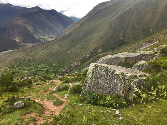
From this place, the view is recreated with the scenic picture in front of it. At our feet the wide plain crossed by the Vilcanota river, with its various green tones characteristic of these rainy months; to the front, the imposing peaks of the Andes, among which Veronica stands out fighting against the clouds to show her white hair.
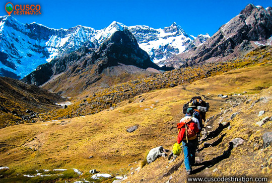
Our descent into the valley is made by the same ramp that the Incas used to slide the pink stone blocks. Along this journey, you can see how some of these stones did not reach their destination; they are known by the name of “Piedras Cansadas”.
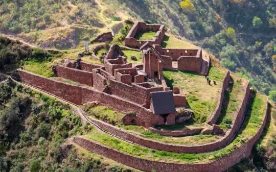
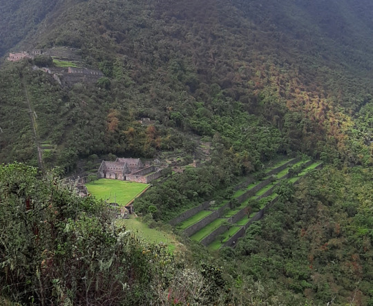
Already entered in the municipality of Ollantaytambo, we had two important archaeological-logical centers to visit: the city and its Inca fortress.
In sector I, the sector of the plaza and temple, hanan area, located to the north and which is the highest part, there are five floor buildings, located on terraces of different levels. It is possible that they served as the residence of the priests. Higher up, there is another smaller plaza where two warehouse buildings (qolqas) and three other long residential buildings are located.
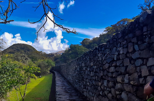
(kallankas). A wall with a main channel of water collected from the Ch’unchumayo stream also enters here, supplying the archaeological site and descending, like a spinal column, organizing the arrangement of the buildings.
In sector II, hanan zone, there are the deposits or qolqampatas divided into warehouses with internal subdivisions with quincha partitions; in another space, within this subsector, there are small ceremonial platforms (16 platforms), crossed by an alternate channel that takes advantage of the waters of the main channel.
Sector III, which appears to be the main square or Hauqaypata, is located between the upper (hanan) and lower (hurin) sectors, on the filling of a platform. On the extreme sides of this square there are buildings with one and two levels. In the north there is a kallanka (building) for ceremonial use — Sunturwasi — with low niches (kind of chapels); To the east are two-story buildings with walls that support gabled roofs. They have two facades, one for entering the main plaza and the other that leads to a patio with side accesses. Access to these buildings is through double jamb covers (a double frame). These buildings are separated by a corridor, which highlights the largest building (kallanka) in the city that goes to the side of the backyard and that leaves through a wall to the south side, which is where the platforms in the north sector are located. of the city or llacta.
Sector IV, located in the Hurin or south zone, is a main construction made up of five covers called by Sartiges “triumphal wall” and by Samanez and Zapata “wall of offerings to the ancestors”. The other four, probably, were for ceremonial use and would correspond to an open temple. Behind these covers is a field, where you enter a second level, which is above the covers.
Sector V is the ushnu: a hill cut at its top that forms a ceremonial oval platform and surrounded by a small wall as a fence, which is entered by an entrance that first rises by steps and from where you can see the main square and hanan site. From this place the snow-capped mountains and the Apurímac river are visible.
Sector VI is the Wasi Cancha, located south of the ushnu in the lower part; It is also known as a temple and home of priests. A space of four platforms with zigzag walls is observed, which was used as a ceremonial space. In the first wall it is finished off with a source for water, and the other platforms are accessed with stairs. Below this area of worship you can see a field or space with two enclosures of one and a half floors enclosed by a perimeter wall; from here you can see a good part of the Apurímac river canyon.
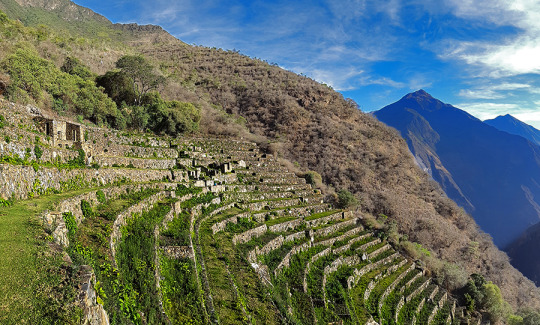
Sector VII belongs to the cultivation platforms on the east side. It stands out from the rest, for being wide and wide platforms. It can be entered through walkways from the main square.
The discovery was made in September 2004 within the framework of the «Cadastre and Delimitation (…)
Sector VIII is an area of cultivation platforms, located on the west side, with eighty platforms, divided into plots and water channels that descend from the main square. Here were the famous “Llamas del Sol”
The ceramic remains show a multi-ethnic presence of the llacta (even though there has been int (…)
Sector IX is made up of popular houses, also called Pikiwasi, and is where one of the water channels ends. The houses seem to have been for collective and family use, built on artificial platforms, rectangular, square and circular in design, communicating by means of stairs and narrow passageways.
Sector X is made up of the cultivation platforms, the Paraqtepata, made up of 18 platforms and irrigation channels parallel to the stairs.
Sector XI also has cultivation platforms, the Phaqchayoq, made up of 80 wide platforms, the largest of the entire complex and located on the right bank of the Ch’unchumayo stream. There are also small quadrilateral enclosures in the middle of the plots with two-level enclosures, both for ceremonial use and for housing, with three sources for water and irrigation channels.
Sector XII presents cultivation platforms three hours away from Hanan Square, and is made up of 57 platforms with permanent irrigation. In the upper part there are buildings for ceremonial use that occupy the entire width of the platform, a spring pool, a semicircular enclosure where ceramic remains, stone tools and bone remains were found.
It is an Inca urban construction, which archaeological studies may be better specifying in the future, as its architectural structure and functions are analyzed. Only archaeologists will determine if there is material evidence with greater antiquity in the same location.56 In a general sense, the Andean populated centers especially Inca also called liadas, are characterized by being fixed according to a distribution pattern: square; a number of large, elongated and rectangular buildings called kallankas; deposits or collqas; platforms or ushnu cradle in their squares for the cult of the Sun and probably to carry the agricultural calendar with more precision (Thompson 1972: 78; cf. also Ayme Carrasco 2003: 237-38, 250-53). According to ethnohistorians, these populated centers followed the model of the city of Cusco, where the ritual and ceremonial spaces had the solar temple, royal apartments and, what we could call, a civil administrative part: prisons, acllahuasis, warehouses (Espinoza 1997b : 362; cf. also Rostworowski 2004: 173). However, it cannot be asserted that there was a general and constant pattern for all urban settlements, Choquequirao is also a good example of the adaptation in a steep and high terrain of a llacta that conserves the fundamental elements, but adequate to a certain area of construction. INFORMATION OF CHOQUEQUIRAO TREK
The urban layout, as seen by archaeologists, follows the dual Andean pattern. There is a high sector: hanan, and another low part, hurin. In this regard, archaeologists Roberto Samanez and Julinho Zapata point out:
When studying the distribution of functions in Choquequirao, a dual organization is perceived, very widespread, which creates a high sector and another low part or Hurin. It has been established that the High Sector is the one occupied by the buildings in the extreme North, and the Low sector is the one next to the main square where ceremonial buildings are located, the three two-level buildings and the two Kallankas. (Samanez and Zapata 1999: 90)
Choquequirao is built following a north-south axis with a drop of 65 meters in height between the first and second planes. Each plan has three groups of constructions that are distributed following the topographic disposition of the terrain. The central area of the complex, probably ceremonial, is 700 meters long.
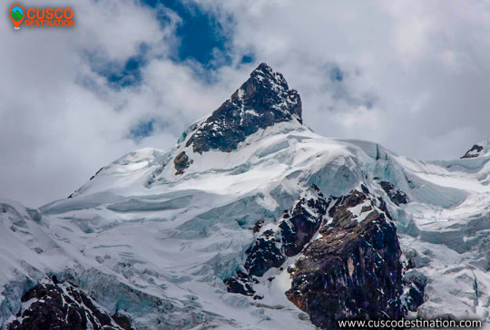
The snow of Ausangate is the fifth highest in Peru and the most representative of the Andes. It is located in the Vilcanota mountain range, it is one of the most difficult areas to access.
The highest peak of this snowfall passes 6,000 meters above sea level, in this place there are large lagoons with blue and green colors, there are also rocks that cause the area to be like a paradise and very modern. This is a very attractive place for people who practice adventure sports, thanks to its geographical accidents it is possible to practice climbing and trekking.
The snowy Ausangate is the representative mountain of Cusco and the Peruvian Andes. It is located in the Vilcanota mountain range and is one of the most difficult areas to visit which makes it a fabulous route to venture. Its main climate is 6,372 meters above sea level, with large green / blue lagoons. In addition there are rocks that make the area like a paradise. Performing the Ausangate trek is an indescribable adventure, and it is impossible not to be impressed by the enormous beauty of eternal snow. Often you will find mountains of a height of more than 5000 meters and also rocks covered with tongues of ice, spreading in magnificent forms forming ice lagoons. The Ausangate walk is one of the tourist destinations in Cusco.
In the Inca mythology of this mountain and the nearby lakes – among which Sibinacocha stands out – the masculine energy that fertilizes Mother Earth Pachamama is born, after a long course, the waters are lost in the unknown lands of the Amazon to return, to fill the lakes and glaciers every night turned into the river of stars or Willkamayu known in the West as the Milky Way The Community of Chillca constituted by shepherds of llamas and alpacas is known as the guardian of these pristine places, from where you can do mountain walks spending the night in comfortable hostels or tambos, among which Machuracay Tambo stand out, in a walk called “Path of the Apu Ausangate”.
Every year on the north side of the Ausangate, the festival of Quyllur Rit’i (Quechua: “star snow”) is celebrated before the feast of Corpus Christi, during which thousands of inhabitants make pilgrimages to the Lord of Quyllur Rit’i in the church from Sinakara. The Ausangate snowy usually takes 7 days tours, it is an adventure that no one should miss.
The first attempt to ascend the snow of Ausangate, was at the beginning of the 50’s, being the first 2 attempts frustrated. It had to wait until 1953, for a German expedition to reach the top of the Apu, ascending on the south side. Later, new routes were implemented to climb to the top of the mountain. Only in 1983, Peruvian feet reached the top of the snow.
Location
It is located in the district of Ocongate, in the province of Quispicanchi, belonging to the department of Cusco in the Vilcanota mountain range.
Climate and temperature
The predominant climate of the area is cold, at night it reaches temperatures below 5 ° C, by day it can be up to 20 ° C, it also has cold winds during parts of the day. In the area there are also rains and snowfall.
Altitude
The maximum peak of the Ausangate snowfall is 6,372 meters above sea level.
How to get to Ausangate Snowy
There are 2 routes to get to the mountain, the first is to go by bus from Cusco to the town of Chilca, from here you can take a walk from 4 to 5 hours to the Base Camp.The other route is a bit longer but cheaper, this is to go from Cusco to the town of Tinki by bus and then take a bus to Pacchanta. From this point along the steel gorge, it is 8 to 10 hours to the Ausangate Base.
Between the snow-capped mountains of Ausangate and Sinakara, is the Coyllur Riti Shrine, popularly known by the inhabitants of the area as Taytacha Coyllur rit’i, whose meaning is Lord of the Shining Snow. Every year here in the months of May or June, the Coyllur Riti festival has been celebrated since ancient times. Celebration during which thousands of Quechua pilgrim to the Lord of Coyllur Riti. This ritual is associated with the fertility of the land and with the worship of the Apus (hills, gods, guardians), one of the largest indigenous nations of America is celebrated.