Tag Archives: travel to choquequirao

Useful information on Choquequirao, the other lost city of the Incas

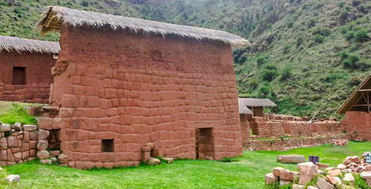
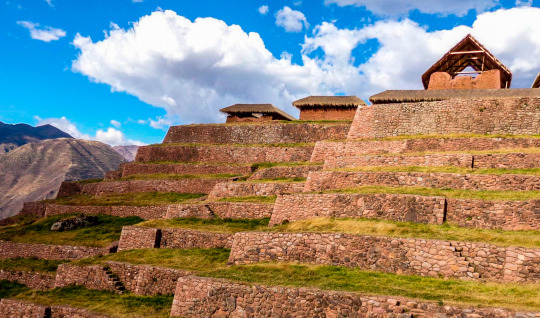
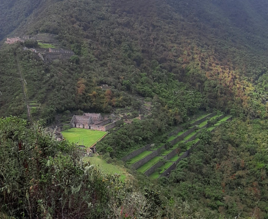
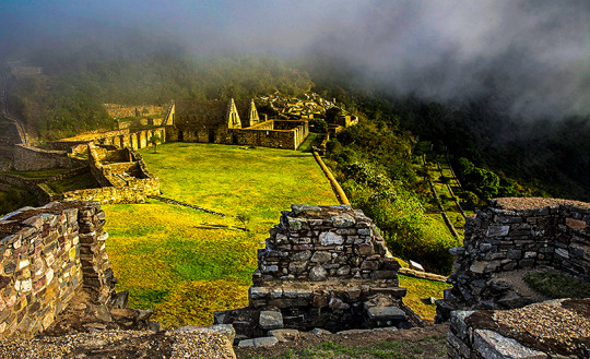
Choquequirao known as the sacred sister of Machu Picchu because it has a structural and architectural similarity, archaeological monuments are made up of terraces distributed on different levels which were leveled and fenced with stones to form a platform with an approximate area of ​​150 square meters.

CHOQUEQUIRAO TREK INFORMATION

Location

The Choquequirao ruins are located at 13 ° 32 ’latitude and 77 ° 44’ west longitude, it is located at 3033 masl in the mountains of the snowy Salkantay north of the Apurímac river in the district of Santa Teresa province of the department of Cusco.

How to get

Currently to reach the last Inca fortress is the land route, the best known route of how to get to Choquequirao is by taking the road to Abancay, and at km 154 choose the detour that will direct you to the town of Cachora.

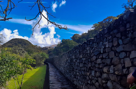
The route to Choquequirao has narrow paths which must be walked very carefully, also have a good physical condition and the proper equipment for this trek.

Weather

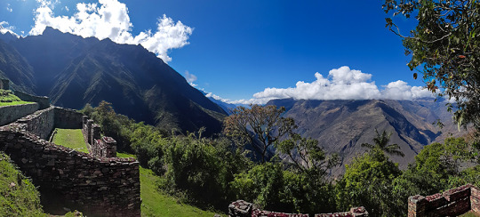
Due to its height, Choquequirao enjoys a temperate climate. However, it should be noted that the Choquequirao path is warm due to the Apurímac canyon.

Description

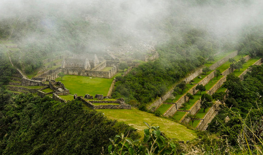
Choquequirao (comes from the Aymara words chuqui, gold, and from Quechua k’iraw, cradle, that is to say: “cradle of gold”), is another of the archaeological zones also known as the Inca citadel, it is located between the ramifications of the Nevado de Salcantay, southern Peru. These archaeological remains of Choquequirao are made up of a set of buildings and terraces distributed on different levels, from the lower Sunch’u Pata level to the highest truncated summit, which was leveled and fenced with stones to form a platform with an area approximately 150 square meters.

Choquequirao (sometimes also referred to as Choqequirau or Choquekiraw), is also known as the “sacred sister” of Machu Picchu for the structural and architectural similarities presented with it. Well, not too long ago it became known about this majestic place, thus awakening the interest of many tourists and researchers.

Biodiversity

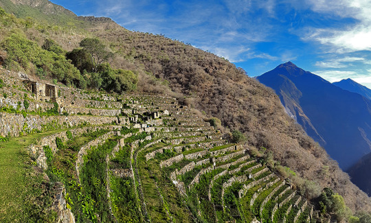
The environment of Choquequirao is one of the richest in biodiversity, biologists, ecologists and experts mention this, however in this area, the number of species of plants and animals that exist is not known exactly, despite this deficiency and From the few scientific studies carried out, it has been possible to determine the existence of various life forms.

Among the most relevant species are: the condor, the fox, the skunk, the puma, the spectacled bear, the taruca, the vizcachas, the pica pica, the tall toucan, the quetzales and the tigrillos. All these species have been conditioned despite the temperature variations such as the sun throughout the day and the inclement frosts at night. This space can also be seen to the cock of the rocks, Peru’s national bird.

The flora of the place is made up of giant ferns and a great variety of orchids, where the wakanki variety stands out. At the bottom of the great valley and under the thermal effect of the water course that runs through it, the forests of the mountain eyebrow provide their warmth and ideal conditions for a huge variety of crops of coca, annatto, corn, cocoa, coffee and fruit trees.

From the environmental point of view, the main value of these presented ecosystems resides in the role played by the exuberant forests that grow in the high parts of the mountains for the maintenance of the water balance of the region, capturing the rainwater and leading it without causing erosion towards the Apurimac River. MORE INFORMATION OF CHOQUEQUIRAO TREK TO MACHU PICCHU


INFORMATION OF THE ARCHAEOLOGICAL COMPLEX OF HUCHUY QOSQO

Description

This complex is the most important archaeological center in the Urubamba valley, after Ollantaytambo and Pisac. The ruins are impressive, although the conservation of the site is inferior to that of Ollantaytambo or Pisac, because they are older.

But unlike the aforementioned places, Huchuy Qosqo has a peculiar architecture: the buildings have been built on polished stone bases with a fine finish, with clay plaster (they are the best preserved parts) and the highest floors are made of adobe. INFORMATION OF HUCHUY QOSQO TREK

A kallanka (rectangular enclosure that could measure up to 70 meters long and that were important state centers where Inca officials stayed) is observed, at least 40 to 50 meters long. Also a remarkable building with two stone floors and an upper one of adobe. There are also large terraces, a very large plaza and a large Inca gate through which a well-preserved path leads from Tambomachay.

The Hispanic chronicles refer that Huchuy Qosqo (probably a site known in Inca times as Caquia Jaquijahuana) was the work and preferred place of the Inca Wiracocha. To this, Maria Rostworoski adds, in her work “History of the Tahuantinsuyo”, that this sovereign established the conquest over the towns of the Urubamba valley and that he chose as his successor his Inca son Urco who, dizzy with power and vices, proved to be totally incapable of ruling. Inca royalty was very confused by this choice and they tried to conspire to impose on another Wiracocha son, Prince Cusi Yupanqui. Social unrest and tension increased every day and to make matters worse, the darkest night fell on Cuzco: the Chancas reached the gates of the capital and were ready to destroy it. It is the year of 1438. Wiracocha abandons the city to his fate and, accompanied by his son Inca Urco, takes refuge in his palaces in the Urubamba Valley, among which was Huchuy Qosqo.

After the Spanish conquest, Gonzalo Pizarro found the mummy that supposedly belonged to the Inca Wiracocha here and ordered to burn it. The descendants of the Inca kept the ashes in a jar that many years later the chronicler Polo de Ondegardo would discover.

Characteristics of the visit

It is possible to visit Huchuy Qosqo in two ways, the first walking from Cusco and Tambomachay along the Inca trail. The other way is going up from the Sacred Valley after crossing the Wilcamayo river (today Vilcanota).

Schedule

Hours (all year)Free access

Choquequirao Archaeological Site and its twelve sectors

Sectors of Choquequirao

In sector I, the sector of the plaza and temple, hanan area, located to the north and which is the highest part, there are five floor buildings, located on terraces of different levels. It is possible that they served as the residence of the priests. Higher up, there is another smaller plaza where two warehouse buildings (qolqas) and three other long residential buildings are located.

(kallankas). A wall with a main channel of water collected from the Ch’unchumayo stream also enters here, supplying the archaeological site and descending, like a spinal column, organizing the arrangement of the buildings.

In sector II, hanan zone, there are the deposits or qolqampatas divided into warehouses with internal subdivisions with quincha partitions; in another space, within this subsector, there are small ceremonial platforms (16 platforms), crossed by an alternate channel that takes advantage of the waters of the main channel.

CHOQUEQUIRAO TREK INFORMATION.

Sector III, which appears to be the main square or Hauqaypata, is located between the upper (hanan) and lower (hurin) sectors, on the filling of a platform. On the extreme sides of this square there are buildings with one and two levels. In the north there is a kallanka (building) for ceremonial use — Sunturwasi — with low niches (kind of chapels); To the east are two-story buildings with walls that support gabled roofs. They have two facades, one for entering the main plaza and the other that leads to a patio with side accesses. Access to these buildings is through double jamb covers (a double frame). These buildings are separated by a corridor, which highlights the largest building (kallanka) in the city that goes to the side of the backyard and that leaves through a wall to the south side, which is where the platforms in the north sector are located. of the city or llacta.

Sector IV, located in the Hurin or south zone, is a main construction made up of five covers called by Sartiges “triumphal wall” and by Samanez and Zapata “wall of offerings to the ancestors”. The other four, probably, were for ceremonial use and would correspond to an open temple. Behind these covers is a field, where you enter a second level, which is above the covers.

Sector V is the ushnu: a hill cut at its top that forms a ceremonial oval platform and surrounded by a small wall as a fence, which is entered by an entrance that first rises by steps and from where you can see the main square and hanan site. From this place the snow-capped mountains and the Apurímac river are visible.

Sector VI is the Wasi Cancha, located south of the ushnu in the lower part; It is also known as a temple and home of priests. A space of four platforms with zigzag walls is observed, which was used as a ceremonial space. In the first wall it is finished off with a source for water, and the other platforms are accessed with stairs. Below this area of ​​worship you can see a field or space with two enclosures of one and a half floors enclosed by a perimeter wall; from here you can see a good part of the Apurímac river canyon.

Sector VII belongs to the cultivation platforms on the east side. It stands out from the rest, for being wide and wide platforms. It can be entered through walkways from the main square.

The discovery was made in September 2004 within the framework of the «Cadastre and Delimitation (…)
Sector VIII is an area of ​​cultivation platforms, located on the west side, with eighty platforms, divided into plots and water channels that descend from the main square. Here were the famous “Llamas del Sol”

The ceramic remains show a multi-ethnic presence of the llacta (even though there has been int (…)
Sector IX is made up of popular houses, also called Pikiwasi, and is where one of the water channels ends. The houses seem to have been for collective and family use, built on artificial platforms, rectangular, square and circular in design, communicating by means of stairs and narrow passageways.

Sector X is made up of the cultivation platforms, the Paraqtepata, made up of 18 platforms and irrigation channels parallel to the stairs.
Sector XI also has cultivation platforms, the Phaqchayoq, made up of 80 wide platforms, the largest of the entire complex and located on the right bank of the Ch’unchumayo stream. There are also small quadrilateral enclosures in the middle of the plots with two-level enclosures, both for ceremonial use and for housing, with three sources for water and irrigation channels.
Sector XII presents cultivation platforms three hours away from Hanan Square, and is made up of 57 platforms with permanent irrigation. In the upper part there are buildings for ceremonial use that occupy the entire width of the platform, a spring pool, a semicircular enclosure where ceramic remains, stone tools and bone remains were found.

MORE INFORMATION OF CHOQUEQUIRAO TREK


Choquequirao archaeological complex – Cusco – Peru

It is an Inca urban construction, which archaeological studies may be better specifying in the future, as its architectural structure and functions are analyzed. Only archaeologists will determine if there is material evidence with greater antiquity in the same location.56 In a general sense, the Andean populated centers especially Inca also called liadas, are characterized by being fixed according to a distribution pattern: square; a number of large, elongated and rectangular buildings called kallankas; deposits or collqas; platforms or ushnu cradle in their squares for the cult of the Sun and probably to carry the agricultural calendar with more precision (Thompson 1972: 78; cf. also Ayme Carrasco 2003: 237-38, 250-53). According to ethnohistorians, these populated centers followed the model of the city of Cusco, where the ritual and ceremonial spaces had the solar temple, royal apartments and, what we could call, a civil administrative part: prisons, acllahuasis, warehouses (Espinoza 1997b : 362; cf. also Rostworowski 2004: 173). However, it cannot be asserted that there was a general and constant pattern for all urban settlements, Choquequirao is also a good example of the adaptation in a steep and high terrain of a llacta that conserves the fundamental elements, but adequate to a certain area of construction. INFORMATION OF CHOQUEQUIRAO TREK

The urban layout, as seen by archaeologists, follows the dual Andean pattern. There is a high sector: hanan, and another low part, hurin. In this regard, archaeologists Roberto Samanez and Julinho Zapata point out:

When studying the distribution of functions in Choquequirao, a dual organization is perceived, very widespread, which creates a high sector and another low part or Hurin. It has been established that the High Sector is the one occupied by the buildings in the extreme North, and the Low sector is the one next to the main square where ceremonial buildings are located, the three two-level buildings and the two Kallankas. (Samanez and Zapata 1999: 90)

Choquequirao is built following a north-south axis with a drop of 65 meters in height between the first and second planes. Each plan has three groups of constructions that are distributed following the topographic disposition of the terrain. The central area of ​​the complex, probably ceremonial, is 700 meters long.

MORE INFORMATION OF CHOQUEQUIRAO TREK